Western redcedar (photo by Nina Munteanu)
In my novel “A Diary in the Age of Water” (Inanna Publications) the diarist writes about the huge reservoir complex that was built in the late 2020s in the Rocky Mountain Trench; they’d created an 800 km long reservoir system to rehydrate the United States.
Of course, it’s science fiction, but it was based on real plans that went all the way to congress in the 1960s. That reservoir might have drowned the rainforest conservation corridor of Robson Valley—a conservation area that continues to experience existential risk due to development, resource harvest, and other disturbance.
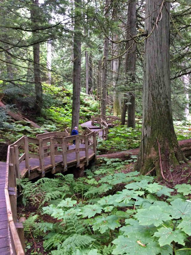
Boardwalk through ancient cedar forest, Revelstoke National Park, BC (photo by Nina Munteanu)
In Robson Valley—tucked between the Rocky and Cariboo Mountains of East-Central British Columbia, the Fraser River nourishes an ancient rainforest matched nowhere on Earth. Massive Western redcedar (Thuja plicata)—some over 1200 years-old, 3.5 meters in diameter, and 45 meters high—thrive in this valley, nurtured by abundant groundwater flow and high humidity for healthy tree growth and reduced fire risk. “Unfortunately, this requirement for growth in wet toe-slope positions has had negative consequences for ancient cedar stands. Historically, roads and railroads were placed at the base of mountain slopes, where easy access on level roadside terrain meant that ancient cedar stands were often among the first sites chosen for logging. Ancient cedar stands now represent less than 5% of forested landscapes within the Upper Fraser River watershed.” (UNBC Plant Ecology)
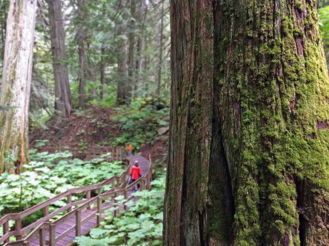
Looking past moss-covered cedar giant to boardwalk, Revelstoke National Park, BC (photo by Nina Munteanu)
This valley contains the most extensive inland rainforest in the northern hemisphere and is the only valley in the Rocky Mountains where grizzly bears still feed on wild ocean-going salmon.

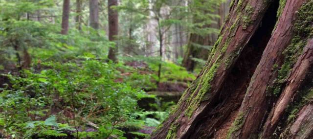
Old buttressed redcedar (photo by Nina Munteanu)
The Save-The-Cedar League also tells us that the Robson Rainforest is oroboreal: mountain-caused with boreal biome characteristics—unlike typical rainforests which are temperate-coastal or tropical. “Antique Forest” is a term used for ancient cedar-hemlock stands that have endured for more than 1000 years. One stand in Primordial Grove can be seen via a well-constructed boardwalk in a small park off Highway 16.
When I entered the ancient forest of magnificent giants with wide buttressed bases, a deep reverence came over me. No other word comes close to describing what I experienced or felt. I was enthralled and humbled by these magnificent trees, silent giants that rose into the mist like sentinels, piercing the heavens. It had rained that morning and the forest dripped with living moisture. Greens of all shades created a living mosaic of hue and texture. Moss covered everything. Lichen dripped off branches and clothed trees in crenulated patterns. The fragrance was intoxicating, a fresh pungency that woke something inside me. The smell has been variously described as “lingering”, “fresh”, “sweet”, “like pineapple when crushed”, or “almost like fresh water.” Even the breeze took on a different voice inside this living cathedral. A kind of deep hush that whispered of sacred grandness.

Looking up at a Western redcedar (photo by Nina Munteanu)
I knew I was in a sacred place.
This ancient forest had been here at least a millennium; long before the arrival of Christopher Columbus to the Atlantic shores of North America. Long before us.
Referred to as “the cornerstone of northwest coastal Indian culture,” the Western redcedar is known as the “tree of life” and “life giver.” Groves of ancient cedars were symbols of power, and gathering places for ceremonies, retreat, and contemplation.
I kept to the boardwalk—to help prevent unwanted trampling and soil compression. The boardwalk snaked past giant buttressed trees that towered several stories high and formed a feathered canopy way above me. Whenever the boardwalk came close to a giant cedar, I had to stop and touch it. The reddish bark was smooth. I smiled; many others had done the same. In unavoidable reverence.
Breathing in the tree’s exquisite fragrance, I scanned my surroundings. A rich understory of red-berried Devil’s Club (Oplopanax horridus), huckleberry, fern, moss, liverworts and dense ground cover painted the forest floor in varying form and colour. I imagined the diversity of invertebrates, amphibians, reptiles, birds and mammals that flourished here. I’m told that scientists are still finding new species in this rainforest. UBC scientists tell us that arboreal lichen communities of the inland rainforest, especially the epiphytic cyanolichen assemblages on conifers, are among the richest in the world.

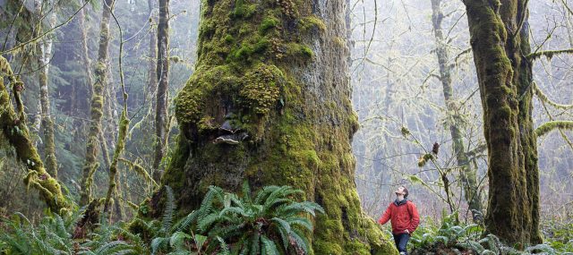
Nina Munteanu leans against a well-loved giant Western redcedar, Giant Cedars Boardwalk Park, Revelstoke National Park, BC (photo by Anne Voute)
Gentle Giant of North Temporate Rainforest: Western Redcedar (Thuja plicata)

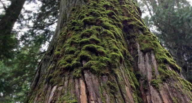
Moss-covered Western redcedar (photo by Nina Munteanu)
The Western redcedar (Thuja plicata) is one of the most magnificent conifers in Pacific Northwest forests (both coastal and inland); it flourishes along the coastal fog belt from Alaska to northern California, and inland from the Pacific Ocean to Montana. The Western redcedar is actually an arborvitae—not a true cedar; acknowledged by its name “redcedar”. True cedars only grow in the Mediterranean regions of the world. “Thuja,” is the latinism for the ancient Greek word for a now unknown, long-lost aromatic evergreen wood; “plicata,” means “folded into plaits,” which may refer to the tree’s characteristic foliage or its furrowed, stringy bark. The heartwood is pink- or red-brown to deep warm brown and highly resistant to moisture, decay and insect infestation due to the oils and acids (polyoxylphenols) it produces; it’s the phenols, in fact, that give off its distinctive pleasant aroma.

Old cedar with extensive root system (photo by Nina Munteanu)
Given their extensive root system, cedars can remain standing long after they die. Western redcedar snags (standing dead trees) can remain intact for up to 125 years. The large snags provide habitat for many cavity-nesting birds and mammals. Many species that require snags for habitats also prey on insects that use trees in a fine balance of a functional ecosystem. Examples include the pileated woodpecker, squirrels, weasels, martens, bats, owls and ducks. A fallen cedar can remain on the forest floor for over a century. “This durability is the result of a natural preservative that is toxic to decay-causing fungi. This ability does not decrease with age; in fact, it increases,” writes Jeri Chase, Oregon forester.
Several of these live ancient cedar trees grow out of the trunks of other live ancient cedars, following a 180 million-year-old pattern observed in the closely-related redwoods (Sequoia). Basal shoots of the trunk yield genetically-superior mature trees when compared to seeds, root sprouts, other shoots or other layering phenomena.
Western redcedar reproduces from root or branch development on fallen trees—the classic “nurse logs” often seen in northwest forests that also nourish other forest species. The magnificent bark of the redcedar ranges in color from grey to reddish brown, and is deeply furrowed, forming long flat fibrous plates that peel and shed easily. Wildlife use the cedar in many ways. The foliage is an important winter food for elk and is browsed year-long by deer and rodents. Black bears den in the hollowed-out trunks of old trees and the cedar-dominated old growth forests provide valuable habitat for spotted owls and Vaux swifts.
Functional Ecosystem & Symbiosis
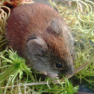
Red-backed vole
The Robson Valley cedar-hemlock rainforest supports a diverse and efficient ecosystem from apex and keystone predator—the grizzly—to black bear, gray wolf, cougar, lynx, wolverine, coyote, and seven ungulate species (including the Mountain caribou); all feeding on a diversity of prey and primary producers. The Mountain caribou feeds on mountain boxwood shrubs which are sheltered by the cedar and hemlock canopy layer.
An example of the symbiotic nature of the old growth cedar-hemlock forest is the red-backed vole, which resembles a large plump mouse. This forest mammal eats truffles—a type of fungus that lives underground. After digesting the truffles, voles spread the fungus around the litter layer of the forest through their droppings. The truffles help tree roots absorb soil minerals and the trees produce sugars necessary for the truffles: a win-win symbiotic relationship. The cedar and the hemlock require this alliance with truffles and voles to grow so large in the nutrient-poor soil.
Una stopped the car and we stared out across the longest reservoir in North America. What had once been a breathtaking view of the valley floor of the Rocky Mountain Trench was now a spectacular inland sea. It ran north-south over eight hundred kilometres and stretched several kilometres across to the foothills of the Cariboo Mountain Range. Una pointed to Mount Mica, Mount Pierre Elliot Trudeau and several other snow-covered peaks. They stood above the inland sea like sentinels of another time. Una then pointed down to what used to be Jackman Flats—mostly inundated along with McLellan River and the town of Valemont to the south. Hugging the shore of what was left of Jackman Flats was a tiny village. “That’s the new Tête Jaune Cache,” my mother told me.
If villages had karma this one was fated to drown over and over until it got it right. Once a bustling trading town on the Grand Trunk Pacific railway, Tête Jaune Cache drowned in the early 1900s when the Fraser naturally flooded. The village relocated to the junction of the original Yellowhead 16 and 5 Highways. Villagers settled close to where the Fraser, Tête Creek, and the McLellan River joined, all fed by the meltwater from the glaciers and icefields of the Premiere Range of the Cariboo Mountains. The village drowned again in 2025. I imagined the pool halls, restaurants, saloons and trading posts crushed by the flood.
“This area used to be a prime Chinook spawning ground,” Una said. “They swam over 1,200 km from the Pacific Ocean to lay their eggs right there.” She pointed to the cobalt blue water below us.
The reservoir sparkled in the sun like an ocean. Steep shores rose into majestic snow-capped mountains. The village lay in a kind of cruel paradise, I thought. It was surrounded by a multi-hued forest of Lodgepole pine, Western red cedar, Douglas fir, paper birch and trembling Aspen. Directly behind the village was Mount Terry Fox and across the Robson valley mouth, to the northeast, rose Mount Goslin. Behind it, Mount Robson cut a jagged pyramid against a stunning blue sky. Wispy clouds veiled its crown. I couldn’t help thinking it was the most beautiful place I’d seen. And yet, for all its beauty, the villagers had lost their principle livelihood and food. The reservoir had destroyed the wildlife habitats and the fishery. And its people with it.
Una pointed to where the giant reservoir snaked northwest and where towns like Croyden, Dunster, and McBride lay submerged beneath a silent wall of water. Her eyes suddenly misted as she told me about Slim Creek Provincial Park, between what used to be Slim and Driscoll Creeks just northwest of what used to be the community of Urling. She told me about the Oroboreal rainforest, called an “Antique Rainforest”—ancient cedar-hemlock stands over a 1000 years old. She described how massive trunks the width of a small house once rose straight up toward a kinder sun. The Primordial Grove was once home to bears, the gray wolf, cougar, lynx, wolverine and ungulates. It was the last valley in North America where the grizzly bear once fished ocean-going salmon. Now even the salmon were no longer there, she said. Then she bent low beside me and pulled me close to her in a hug. She quietly said to me, “This is what killed Trudeau.”
I stared at her and firmly corrected, “but that was an accident.”
“Yes,” she agreed. Then added, “a planned one.”
Moss-covered Western redcedar, Revelstoke National Park, BC (photo by Nina Munteanu)
NAWAPA (North America Water Power Alliance)
 The original NAWAPA Plan was drawn up by the Pasadena-based firm of Ralph M. Parsons Co. in 1964, and had a favorable review by Congress for completion in the 1990s. The plan—thankfully never completed—was drafted by the US Army Corps of Engineers and entailed the southward diversion of a portion (if not all) of the Mackenzie and Yukon rivers in northern Canada and Alaska, now flowing into the Arctic Ocean as well as the Peace, Liard and other rivers flowing into the Pacific by creating massive dams in the north. This would cause the rivers to flow backwards into the mountains to form vast reservoirs that would flood one-tenth of British Columbia. The water would be channeled south through the 800-km Rocky Mountain Trench Reservoir into the Northern USA, and from there along various routes into the dry regions of the South, to California and reaching as far as Mexico.

NAWAPA was envisioned as the largest construction effort of all times, comprising some 369 separate projects of dams, canals, and tunnels, for water diversion. The water diversion would be accomplished through a series of connecting tunnels, canals, lakes, dams, and pump-lifts, as the trench itself is located at an elevation of 914 m (3,000 feet). To the east, a 9 m (thirty-foot) deep canal would be cut from the Peace River to Lake Superior. Its largest proposed dam would be 518 m (1,700 feet) tall, more than twice the height of Hoover Dam (at 221 m) and taller than any dam in the world today, including the Jinping-I Dam in China (at 305 m).
Conspiracy theorist and convicted fraudster Lyndon LaRouche was a principle proponent of the environmentally destructive NAWAPA plan. Although the plan was scrapped in the 1970s due to environmental concerns, it resurfaced in 1982 particularly by Parsons engineer Roland Kelley, who wrote a report called NAWAPA Plan Can Work. LaRouche and his movement revived interest more recently. In 2012 the LaRouche Political Action Committee released their NAWAPA XXI special report, which contained a detailed plan for the revival of an updated and expanded version of NAWAPA. The LaRouche movement continues to promote this outlandish plan today with support from various American politicians and industrialists.
In his book Cadillac Desert, environmental writer Marc Reisner described the plan as one of “brutal magnificence” and “unprecedented destructiveness.” Historian Ted Steinberg suggested that NAWAPA summed up “the sheer arrogance and imperial ambitions of the modern hydraulic West.”
An entire ecosystem on one tree (Sitka Spruce in Massome Grove, near Port Renfrew–photo by Ancient Forest Alliance)

Nina Munteanu is a Canadian ecologist / limnologist and novelist. She is co-editor of Europa SF and currently teaches writing courses at George Brown College and the University of Toronto. Visit www.ninamunteanu.ca for the latest on her books. Nina’s bilingual “La natura dell’acqua / The Way of Water” was published by Mincione Edizioni in Rome. Her non-fiction book “Water Is…” by Pixl Press (Vancouver) was selected by Margaret Atwood in the New York Times ‘Year in Reading’ and was chosen as the 2017 Summer Read by Water Canada. Her novel “A Diary in the Age of Water” will be released by Inanna Publications (Toronto) in 2020.

One thought on “A True Rocky Mountain Gem: The Antique Forest of Robson Valley”