Giant white pines rise high above me like columns of a sacred cathedral. Their deep green canopies sway and creak in the breeze as they strain toward the heavens. Below, at my feet, a profusion of ferns and forest plants lie in the dappled light of the understory. A hermit thrush offers its tender ode to the forest. A pure song that opens from a singular note into successive waves of pure light.
It is heavenly magic.

Trail through white and red pine forest of bracken fern and Sarsparila in Petroglyph Provincial Park, ON (photo by Nina Munteanu)
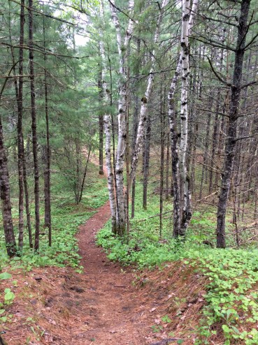
Trail through birch-pine forest (photo by Nina Munteanu)
I’m walking with a friend along the Nanabush Trail through swamp forest toward Minnow Lake in Petroglyph Provincial Park. The swamp to my right was beaver-made and spreads out north from the path in a swath of reeds and grasses. We had earlier passed through a rocky ridge area, thinly covered with herbs and grasses, lichen (reindeer moss) and moss. We then descended through birch, trembling aspen, white pine, white spruce and red maple forest. Bracken fern, wild sarsaparilla, twinflower and club moss covered the ground in textures and filigrees of green and gold.
We had driven north from Peterborough, along Highway 28 into the southern edge of the Canadian Shield, which starts at Burleigh Falls. This is the land of pink granite and white pines. Outcrops of Precambrian igneous and metamorphic rocks were visible from the road as we made our way to Petroglyph Park.
 Petroglyph Park spans about 1.5 thousand hectares of mixed forest in the Great Lakes-St. Lawrence Lowlands Forest Region. The park is a sought-after destination for its impressive petroglyphs (rock carvings) by ancient Algonkians that date back to prehistoric times over an area of subterranean streams.
The glyphs were estimated to have been carved 900-1400 AD by the Ojibwa of the Algonkian linguistic group in the Late Woodland Era. Holes in the rock were considered entrances to the spirit world, situated directly beneath the surface (spirits prefer to live near water). The petroglyphs—some 1,200 of them—had been carved in limestone using gneiss hammers.
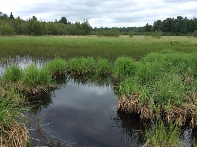
Marsh near Mirror Lake, Petroglyph Park, ON (photo by Nina Munteanu)

Northern water snake (photo by Merridy Cox)
We didn’t have access to the petroglyph site, which was closed due to the COVID pandemic. Instead, we hiked parts of the large pristine forest of trails and boardwalks through marsh and to several lakes.
On the trail to Minnow Lake, we got as far as the first boardwalk across the large marsh. Here, in the open marsh of equisetum (horsetail), rushes and sedges, and ferns, Merridy spotted a water snake, which she identified as a northern water snake.
McGinnis Lake, a Meromictic Lake

McGinnis Lake, a meromictic lake in Petroglyph Park, ON (photo by Nina Munteanu)
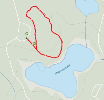
Short loop trail to McGinnis Lake (from All Trails)
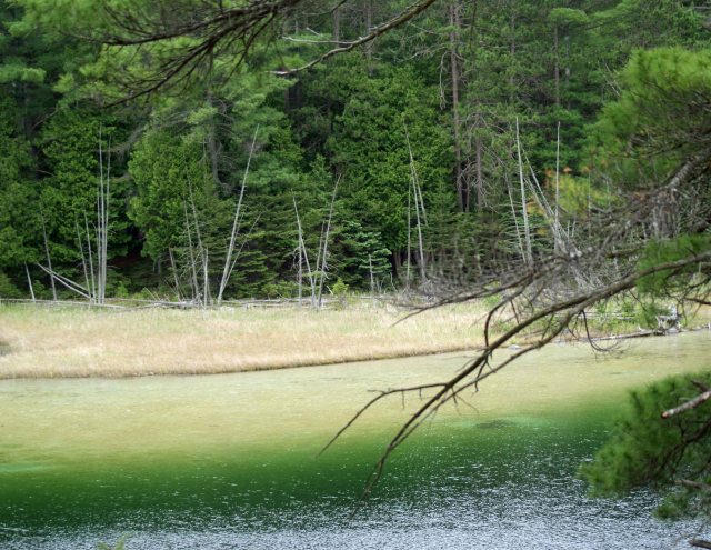
The less than 2 km loop trail to McGinnis Lake from the west day use parking lot took us through dense white and red pine forest. We passed pink granite outcrops in the soft limestone and found ourselves on a rocky promontory on the north side of the lake that overlooked the over 12 m deep lake. The 4.4 ha lake’s water was a deep blue-green jade colour rimmed by shallows of lighter green that graded to a cream colour. Rocks, logs and large shore debris hung precariously over the steep sides of the lake below us, covered in creamy marl.
On the opposite south side of the jade-coloured lake—accessed by the east day use parking lot, the marl-covered shallows extended further out, creating a stunning visual colourscape that shifted from deep blue-green to yellow and cream.
View of south side of McGinnis Lake from rock promontory, showing marl deposits in the shallows (photo by Merridy Cox)
The information sign on the promontory described McGinnis Lake as a rare meromictic lake. I’d studied meromictic lakes at university as a limnology student; I’d never actually seen one before. Until now.
Meromictic lakes aren’t just rare; they are fascinating in the study of lake formation, type and function.
Many lakes in the northern temperate area of Canada are dimictic: they mix completely (holomixis) twice a year, once in the spring and once in the fall. In shallow lakes, warmed by the sun and mixed by the wind, wind-driven currents keep the water mixed all year round. In deeper lakes, the currents can’t compete with the active summer warming of the upper water mass and density differences develop between upper and lower waters. The lake stratifies into an upper epilimnion and lower hypolimnion, separated by a metalimnion or thermocline barrier. In the fall, with cooling, the density barrier breaks down and the wind-driven currents penetrate into the lower layers to thoroughly mix the lake to the bottom sediments (holomixis) in what’s called lake turnover or overturn.
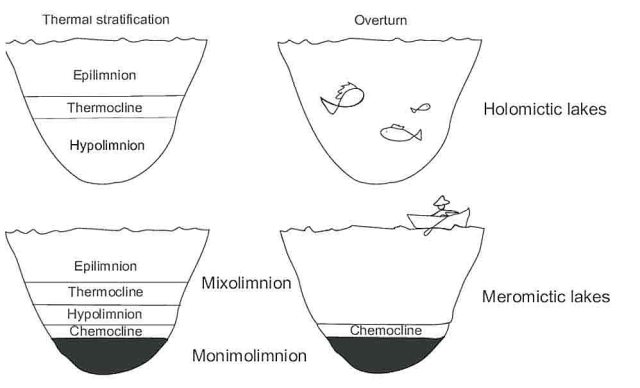
Unlike dimictic lakes, meromictic lakes experience incomplete vertical mixing of only the upper water mass during the circulation period (called meromixis). The upper water mass (mixolimnion) mixes twice yearly like a dimictic lake; however, below this upper mixing layer lies a salinity barrier known as a chemocline (where dissolved oxygen decreases markedly with depth) and beneath it lies the anoxic water mass known as the monimolimnion, which experiences a fairly constant temperature and higher salinity. The higher dissolved salt at the bottom—and greater associated water density—prevents wind-driven mixing of this bottom quiescent layer and accumulates hydrogen sulfide and methane.
Cross-sectional diagram of a typical meromictic lake (taken from Anderson et.al., 1985)
Lake morphology—particularly the relationship of depth and surface area—contributes largely to whether a lake is meromictic and capable of preserving undisturbed laminated sediments.
A meromictic lake may develop if it contains a deep hole in a shallow basin or is sheltered from the prevailing wind by tall vegetation or other barriers—like McGinnis Lake, which rests in a steep-sided limestone basin, sheltered from the winds by a dense pine forest. McGinnis Lake may have formed through karst erosion; it may also simply occupy a deep glacial trough. Because of the barrier and lack of mixing, any exchange of dissolved materials from the lower quiescent layer into the mixing layer occurs very slowly through eddy diffusion across the chemocline. This makes Lake McGinnis’s monimolimnion a nutrient sink and why it is, like most meromictic lakes, unproductive (oligotrophic).
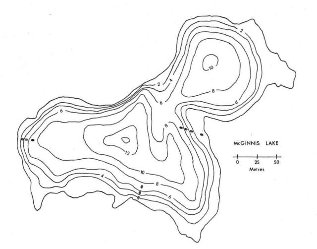
Morphometry of McGinnis Lake (taken from Cheek, 1979)
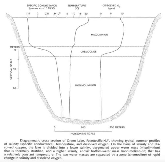
In summer, when McGinnis Lake is stratified, the top 6 m layer of the lake reaches 20-22˚C and its middle 6-12 m layer is typically 7-12˚C. However, below the chemocline, the anoxic monimolimnion (below 12 m), stays a constant 5-6˚C year-round, and is a pinky-brown colour. Few organisms live in the oxygen-depleted monimolinion. An exception are the cyanobacteria (Cyanophyceae), autotrophic bacteria that can survive on hydrogen sulfide at the lake bottom and are responsible for lime depositing in lakes.
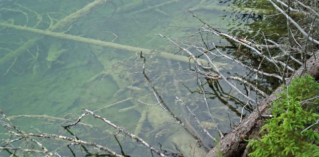
Sunken trees covered in marl on the northern shore of McGinnis Lake, ON (photo by Merridy Cox)
Brilliant Jade Colour

Looking southwest from rock promontory, McGinnis Lake (photo by Nina Munteanu)
The intense jade colour of marl-based McGinnis Lake is partially explained by the presence of calcium carbonate (CaCO3) in the lake from marl—calcium carbonate and clay. The dominant carbonate mineral in most marls is calcite, along with other carbonate minerals such as aragonite, dolomite and siderite. Marl formation and settling is encouraged by bacteria, phytoplankton, and periphyton (attached algae) as temperatures increase in summer. The calcium carbonate—which is present in the limestone bedrock surrounding the lake—acts like a flocculent to clear the lake of the coloured, dissolved substances; as the brown hue is removed, blue and green light can penetrate into the deepest parts of the lake. The most brilliant jades can be seen when the microscopic algae thrive and when the suspended marl increases in volume in mid to late summer.

Stalked Gomphonema (diatom) on Oedogonium (taken from Centre for Freshwater Biology, University of New Hampshire)
Presence of marl is also why the water-sunken trees and debris and the entire shoreline are covered in a milky cream-coloured floc—likely a combination of marl deposit and periphyton (attached encrusting and filamentous algae) that help deposit the marl. Examples may include stalked diatoms (Gomphonema) and blue-green alga Oedogonium. The periphyton secrete glycocalyx (fibrous meshwork of carbohydrates) and other mucilage secretions that coat the sediment particles and adsorb organics and other nutrients for their use. This is why the lake’s shallow shores are a dramatic cream-yellow colour and grade to a brilliant green then deep blue-green of deeper overlying waters. Marl are tiny white coloured crystals and as the water warms in the day, so does the volume of crystals in the water. As the summer progresses, the clear deep blue of McGinnis Lake may transform into lighter milkier turquoise with suspended calcium carbonate crystals.

Undisturbed Sediments & Varves
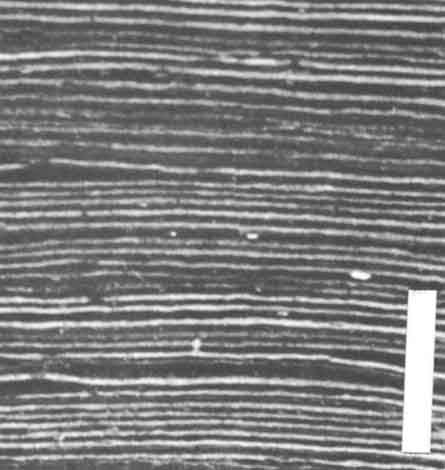
Varves (sediment layers) of Elk Lake, a meromictic lake (taken from Anderson et.al., 1985)
Because a meromictic lake’s bottom water layer doesn’t mix and is permanently anoxic (without oxygen), no burrowing benthic organisms are present to destroy the sediment layers (varves) laid down over time—mostly organics that don’t decay. Because of this, these varves provide an undisturbed history of biological succession and climate change of the last 10,000 years.
Undisturbed annual sediment laminations of a lake can provide accurate chronology, just like tree rings, over thousands of years, dating back to the late Pleistocene and Holocene 10,000 to 12,000 years ago. This is because sediment accumulation—just like tree growth—often follows a seasonal pattern. Annual accumulations of sediment may consist of a simple two-component couplet (summer vs. winter sedimentation). In summer increased photosynthesis causes settling of CaCO3; while in winter, when the lake is ice-covered, fine organic material and clay settles to the bottom.
Varve couplets (summer-winter layers of a year) typically consist of a dark layer of organic sludge with algal filaments, iron sulfides, and clay that grades upward into a lacy network of diatom frustules and organic matter; this would be overlain by a light layer of diatom frustules and calcite that turns into pure calcite at the top.
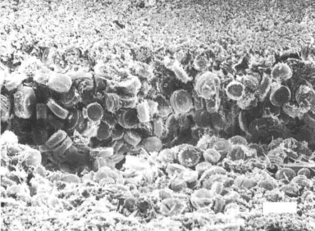
Diatoms in a sediment varve of Elk Lake (taken from Anderson, et.al., 1985)
In summer, calcium carbonate and diatoms (algae with silica shells) accumulate on the bottom; in winter more fine organic matter and clay settle.
References:
Anderson, Roger Y., Walter E. Dean, J. Platt Bradbury, and David Love. 1985. “Meromictic Lakes and Varved Lake Sediments in North America. USGS Bulletin 1607.
Burkholder, JoAnn M. 1996. “Interactions of Benthic Algae with Their substrata. B. The Edaphic Habit: Epipsammic and Epipelic Algae among Sands and Other Sediments. Algal Ecology: Freshwater Benthic Ecosystems, R. Jan Stevenson et al., editors. Academic Press. 753pp.
Cheek, Michael Ross. 1979. “Paleo-indicators of Meromixis.” M.Sc. Thesis, Brock University, St. Catherines, Ontario. 129pp.
Stewart, K.M., G.E. Likens. 2009. “Meromictic Lakes.” In: Encyclopedia of Inland Waters, G. E. Likens, editor-in-chief. Academic Press. 2250pp.
Wetzel, R.G. year. 1960. “Marl Encrustation on Hydrophytes in Several Michigan Lakes.” Oikos 11 (2): 223-236.

Marl-covered south shore of McGinnis Lake, ON (photo by Merridy Cox)

Nina Munteanu is a Canadian ecologist / limnologist and novelist. She is co-editor of Europa SF and currently teaches writing courses at George Brown College and the University of Toronto. Visit www.ninamunteanu.ca for the latest on her books. Nina’s bilingual “La natura dell’acqua / The Way of Water” was published by Mincione Edizioni in Rome. Her non-fiction book “Water Is…” by Pixl Press (Vancouver) was selected by Margaret Atwood in the New York Times ‘Year in Reading’ and was chosen as the 2017 Summer Read by Water Canada. Her novel “A Diary in the Age of Water” was released by Inanna Publications (Toronto) in June 2020.

I was just there on the weekend. (A regular hiking spot). Enjoyed the information on McGinnis Lake. I knew it was Meromictic, but the further explanation was helpful. Many trees down on the trail from the November winds. (I counted 44 trees I had to go over/around)
LikeLiked by 1 person
That’s a lot of trees! I am hoping to go back and do a larger loop trail in the spring. I’m glad my explanations were helpful. I was overjoyed to see this kind of lake–finally! I hadn’t yet in all my years as a practicing limnologist…
LikeLike
FYI: This is a large perimeter loop joining the smaller loops: If you go in the spring before the park officially opens, you can park at the gate and walk in the road (stay left where it splits) and walk past McGinnis Lake to the Day Use Trails not far past McGinnis. (trails on your left). That trail splits immediately, stay left and walk to where it joins the larger Marsh Trail. Left on that trail to Minnow Lake Trail. Left onto Minnow Lake trail, around Minnow Lake and back to Marsh Trail. Left on Marsh trail back to trailhead near parking area. (large sign). Keep on the Marsh trail (now heading back towards the park gate) until you reach the Day Use Trail. Left on that trail back to the road, and then back out to the car. It’s about 2 1/2 hrs. at a fair clip. Maybe 8-10k? Trails are easy to follow, with signs at junctions.
LikeLiked by 1 person
I was curious about the forming of McGinnis Lake and that led me to your blog after a bit of Google search. I’m so happy that I find your blog, I have learned a lot from your writing. I’m a geotechnical technician with a little mix of environmental work but I knew nothing of limnology. Thank you so much!
LikeLiked by 1 person
Hi Joe, thanks for your comment and your interest in McGinnis Lake. Do check out my other posts on limnology if you are curious. Just type in “limnology” in the search bar and you’ll find several pieces… All the Best, Nina
LikeLike
Great article, local resident down the road from the Petroglyphs. Only error I saw was that the geology in which McGinnis lake is situated is in a transitional zone from carbonates (marble) to syenites. Thank for the information on this lake. This place has been a special place for my ancestors for many generations, and it is no suprise why.
LikeLiked by 1 person
Thanks for your comments, Corey. Your correction is duly noted. Thanks for that too. 🙂 Best, Nina
LikeLike
I visited this little wonder just a few days ago. Wish I had seen your blog earlier. I did scant research before going which is basically the definition of meromictic lakes. I am so glad I visited and I thank you for sharing your knowledge through your very informative blog.
LikeLiked by 1 person
It is a wonderful place, isn’t it? As a limnologist, particularly,I was so enchanted by it. Thanks for your note, Bibi! All the Best, Nina
LikeLike