Perhaps some might think this a simple question. It might be; but the answer is far from simple…
.
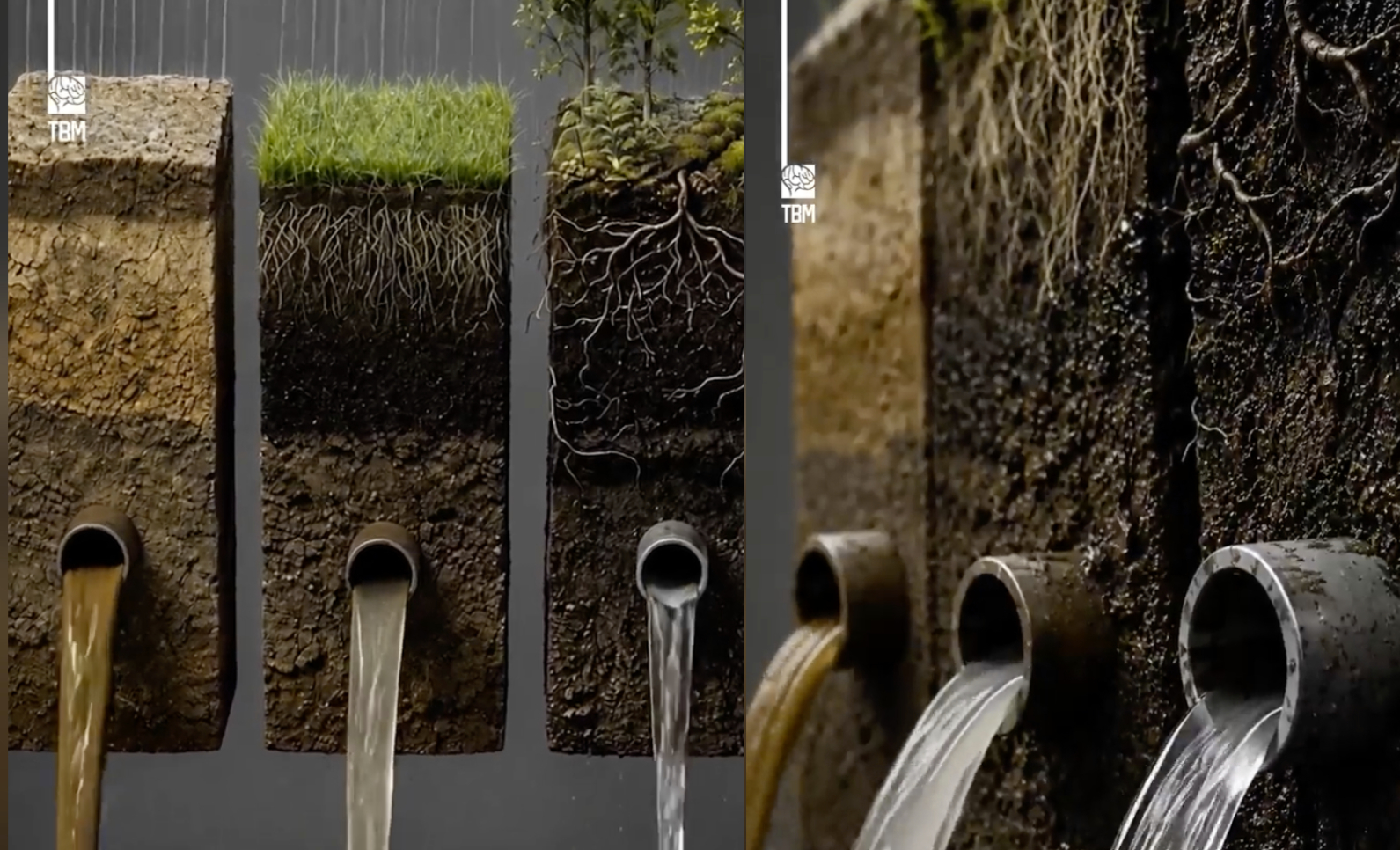
What happens to the rain when it meets the earth depends on many factors and plants are a chief determinant. The filtering effect of plants on rainwater is vividly shown in the recent photo essay put out by the organization Climate Action, which spotlights COP31 and the 2026 UN Climate Conference.
They show quite graphically how vegetation helps slow runoff, protect and anchor soil and filter water before it reaches a river or groundwater. They compared bare soil, a grassy field and ground covered in shrubs and trees. The results were dramatic:
Water falling on bare soil ran off rapidly, carrying sediments and pollutants and increasing erosion and flood risk. The runoff was lessened with ground covered in grass and least by ground with organic litter and substantial vegetation with significant root structure.
Vegetation works on water’s movement both above ground and below ground.
Above-ground vegetation intercepts rainfall and slows its movement. Raindrops that hit leaves, stems and other plant parts slow their trajectory and get redistributed; the velocity of their impact on the ground is reduced. These interruptions allow water to soak into and feed the soil, preventing erosion and muddy contaminated runoff into local streams, rivers and lakes. Ground cover traps pollutants, catching debris and heavy metals before they seep into the ground.
Roots anchor soil particles and stabilize the ground. Along with associated fungi and microorganisms, a healthy root network filters out organic and inorganic contaminants like heavy metals (called phytoremediation) and helps retain and transform nutrients for plant use.
.
Slowing the Water Cycle
Put most simply, vegetation slows water down so it can do its work in the water cycle. Water must move, but it has an optimum speed for ecosystem wellness.
.
.
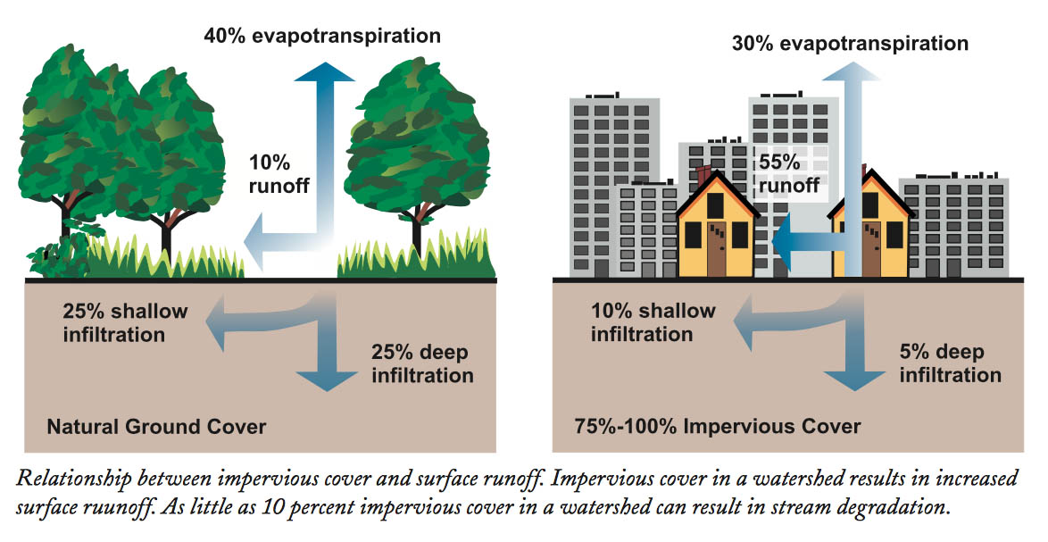
Slowing the water cycle allows water to do its work well. Slow movement underpins a healthy water cycle. A fast water cycle prevents healthy soil infiltration and promotes runoff, erosion and unnecessary flooding. This is what happens in most urban areas where increased impervious surfaces have sped the water cycle, goading it to reach breakneck speeds. The most efficient and frankly the easiest way to slow the water cycle down is to cover surfaces with vegetation—preferably not lawn.
.
.
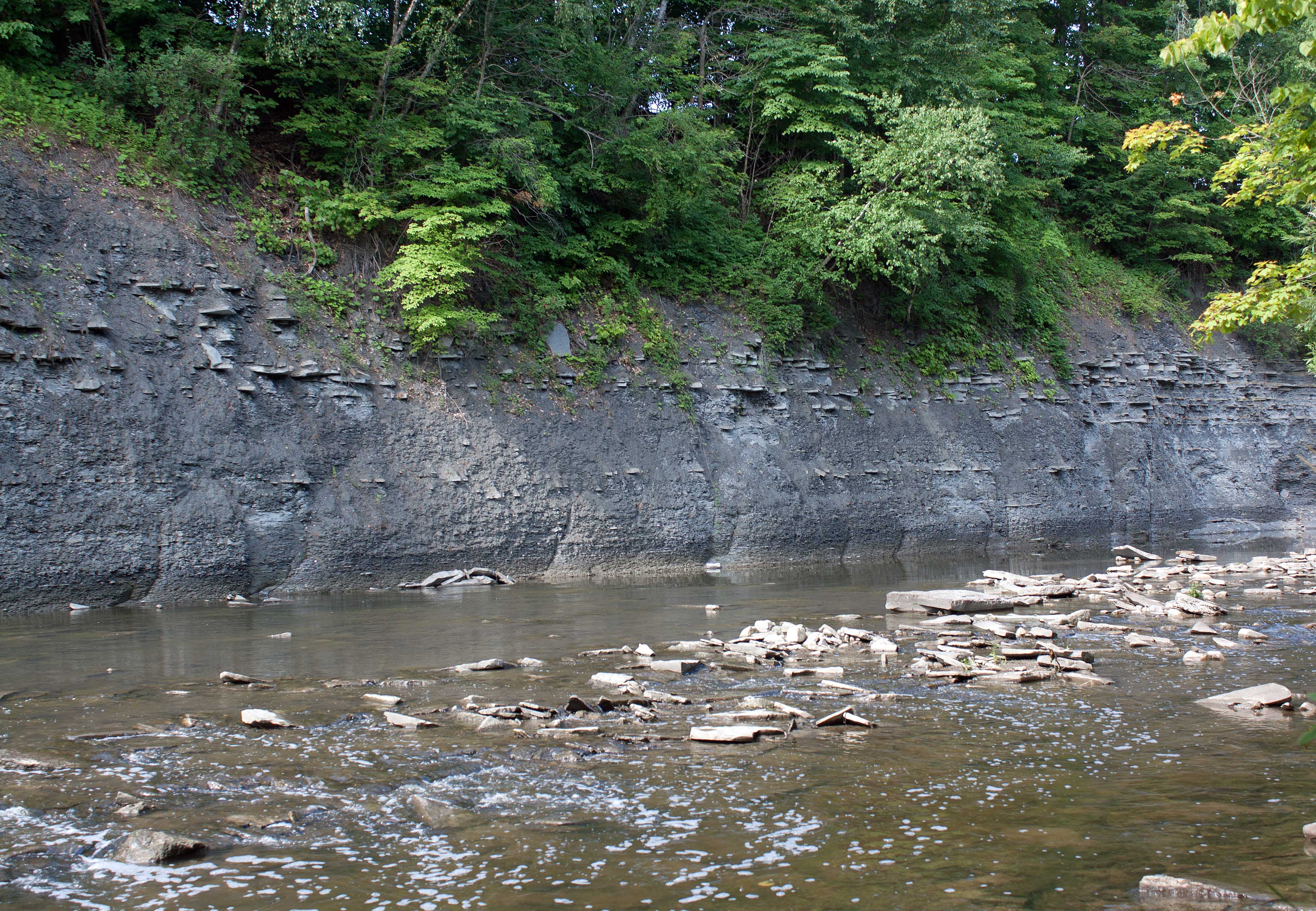
Steeper landscapes are most susceptible to erosion and slumping once vegetation has been removed. Two examples, which I observed, include the ravines of the East Don River and Etobicoke Creek in Toronto and Mississauga, Ontario. Both rivers have suffered significant erosion, bank slumping and contamination due to vegetation removal (particularly wetlands) and urban development far too close to waterways. The Don, particularly, experiences massive flooding every few years. This can be directly attributed to channelizing sections of the river, creating impermeable surfaces too close to ravine slopes along with removal of native trees and shrubs, and removal of natural wetlands and riparian vegetation.
.
Rain and Non-Point Source Pollution / Erosion
.
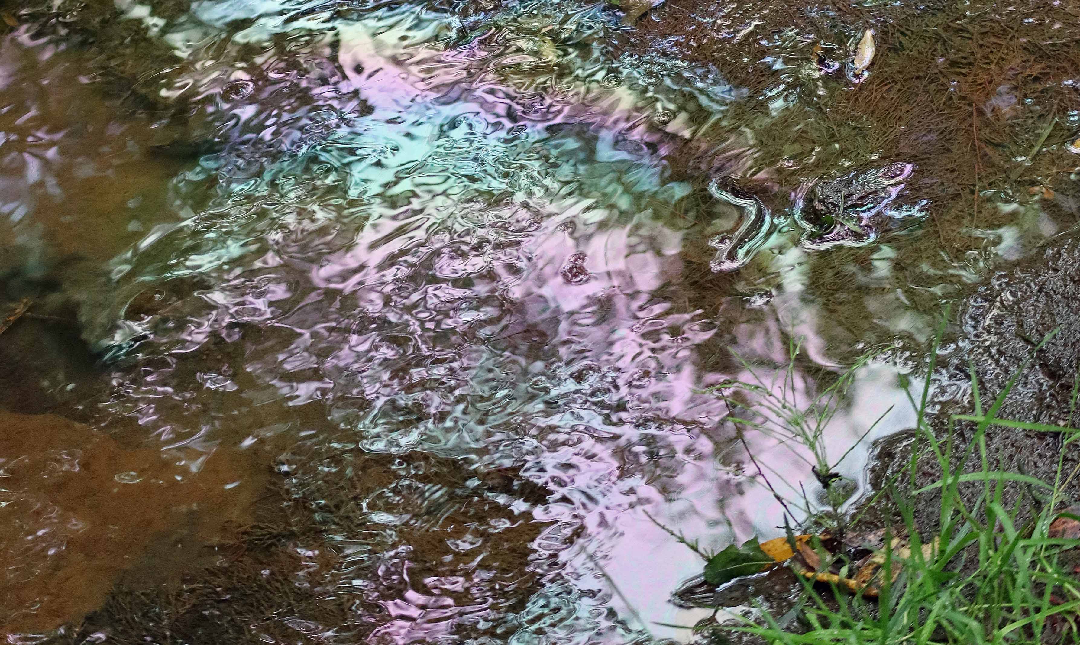
In Peterborough, Ontario, which gets its drinking water from the unprotected Otonabee River, I witnessed several places where the riparian buffer was next to nothing and unregulated runoff streams brought questionable things to the drinking water river. Significant sections of the river ran within two meters of roadways and buildings and receive runoff from non-point sources (as opposed to point sources from an outfall or pipe), usually a mix of origins from properties, and traffic; a result of rainfall picking up contaminants from mostly impervious surfaces and transporting them to a waterway.
The leading non-point pollution is erosion and sedimentation: the movement of soil as water flows too quickly across the ground—a direct result of not enough undisturbed riparian vegetation.
.
Rainfall and Riparian Protection
.
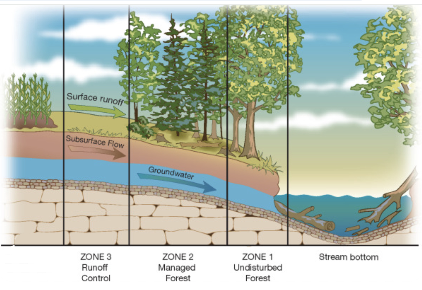
When rain falls, it either percolates through the ground eventually as subsurface flow and groundwater flow or goes straight to surface flow. Rain’s pathway depends greatly on the surface it first finds–whether it’s vegetation, ground or concrete. Watercourses are naturally protected by their naturally vegetated shorelines.
Using its authority through the Fisheries Act, Fisheries and Oceans Canada requires by law that a sufficient buffer of undisturbed vegetated land exist to the shores of all watercourses. Unfortunately, this only applies to a watercourse occupied by anadromous fish (the regulatory incentive of the Act). For any other watercourse, provincial and municipal regulations apply; and these vary incredibly from province to province; in many cases regulations are not properly enforced and development loopholes are exercised.
Too heavy a reliance is typically made on the presence of fish in a stream to dictate the level of protection; as though other aquatic life and associated terrestrial life weren’t important. As though water health on its own is not important…
The role that clean moving water plays in the general wellbeing of a watershed and its inhabitants through its physical and chemical presence is largely ignored (e.g. local air quality, humidity and weather, generation of negative ions, and ecosystem resilience). See my book Water Is… for more on this life-giving substance.
.
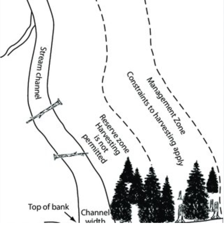
British Columbia regulates streamside and waterfront areas under the Riparian Areas Protection Regulation (RAPR). The regulation protects 30 metres on both sides of a stream or the high-water mark. A watercourse is seldom protected by a 30 m barrier of undeveloped riparian land. Developers and property owners planning residential, commercial or industrial work near a watercourse can hire a QEP (Qualified Environmental Professional) whose environmental assessment then defines the required extent of the protected strip (the SPEA or Streamside Protection and Enhancement Area) where vegetation must remain undisturbed to protect habitat, shade water, and prevent erosion. This protective leave strip can be reduced to 2-5 metres based on on-site fieldwork that calculates the Zone of Sensitivity (ZOS). Municipalities may further ameliorate through local zoning and development permits.
(image by BC Government)
.
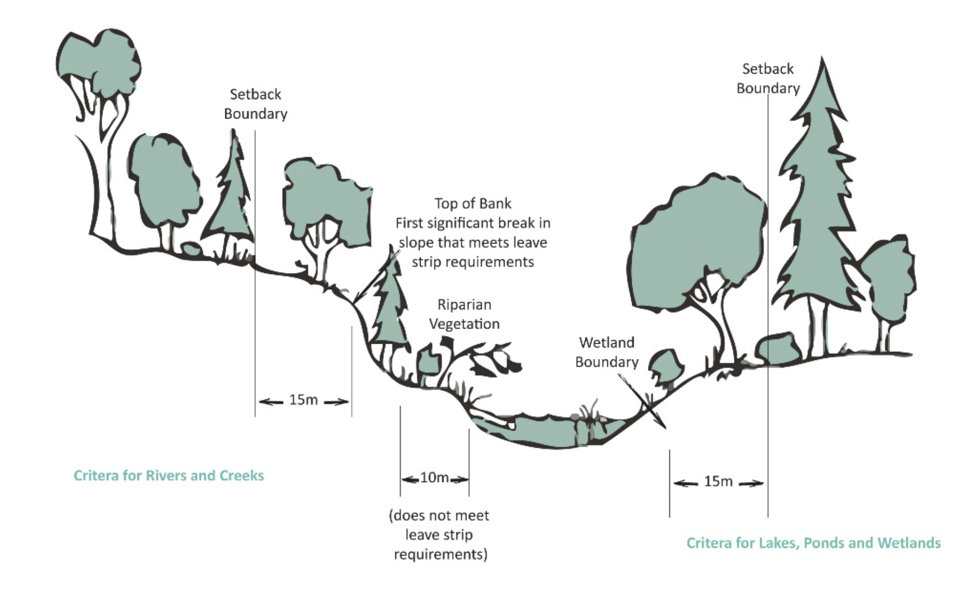
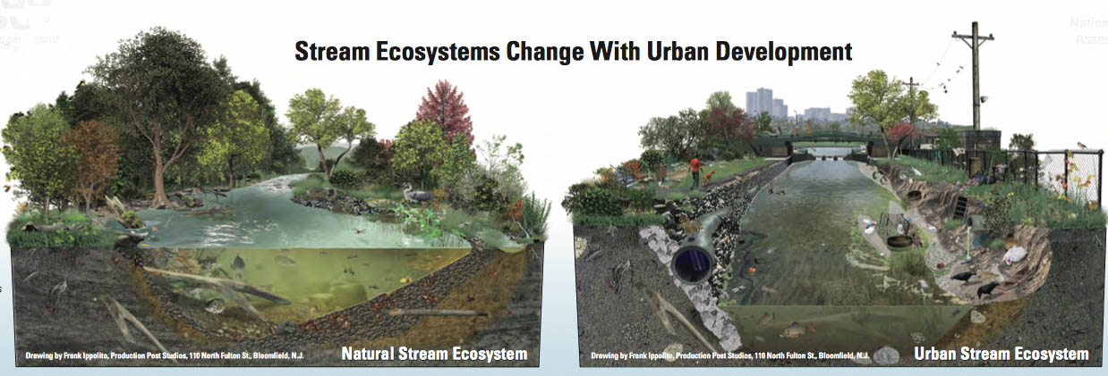
While the regulations on riparian habitat appear good, they seem to break down just where they may be needed most: in places of potentially high development and contamination through non-point urban runoff: the ditches, storm water drains, and various runoff channels that potentially carry a serious cocktail of toxic urban contaminants from industry and households alike.
.
Detailed Assessment of the ZOS
Detailed field assessments to calculate the Zone of Sensitivity (ZOS) and required Streamside Protection and Enhancement Area (SPEA), are conducted by a Qualified Environmental Professional (QEP) who measures aspects of the watercourse such as channel width, slope and type, and reach breaks. The QEP measures properties of the terrestrial riparian area that protect and nurture the aquatic ecosystem, including providing:
- Shade (which regulates water temperature)
- Large woody debris (LWD) and bank stability (which prevent erosion and provides aquatic habitat structure)
- Litter fall and insect drop (which supply organic nutrients and food for both the terrestrial and aquatic ecosystems)
Factors that influence the calculations of a ZOS include slope stability and potential wind-throw as well as the assessed ‘quality’ of the watercourse itself—whether it is a natural stream, wetland, or constructed ditch (considered of less value)—and the ‘quality’ of the existing riparian vegetation. I use single quotes on the word ‘quality’ because this designation is key to decisions on protection and relies on the “opinion” (BC Government word) of the expert making the field observations. Unfortunately, this ‘expert’ may be anyone from a qualified limnologist or aquatic ecologist (a RPBio) to a technologist with limited ecological knowledge whose work is simply signed off by someone in the office who is a Registered Professional Biologist (yes, that’s cheating and I’ve witnessed consulting firms in BC and Ontario do this).
.
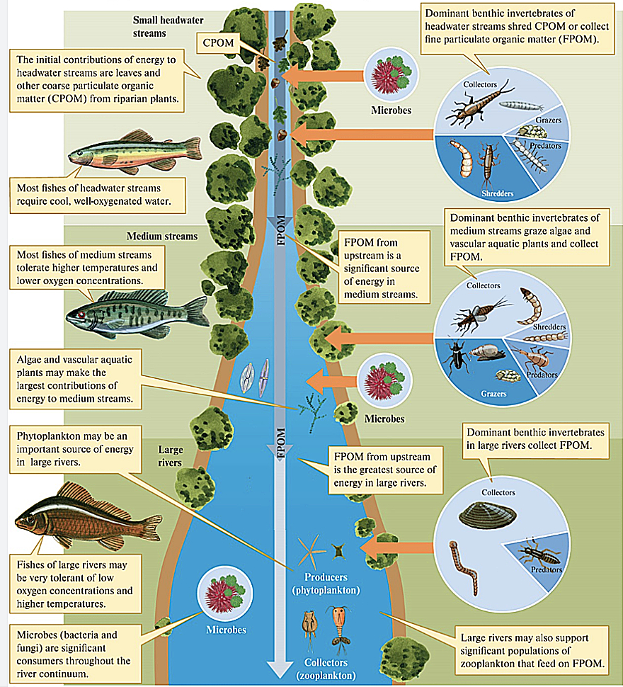
Protecting the Entire River: The River Continuum Concept
.
As a result, variability in setbacks may run counter to logical protective measures. I know; I worked as an environmental consultant in British Columbia and Ontario for over twenty years. All to say that strict use of environmental protective science may run afoul based on political, social, and economic forces. A case study in southern Costa Rica determined that riparian buffer length was more influential than width on river water quality. The study highlights just one problem with variable protection of a watercourse, its watershed and immediate riparian area. See my discussion of the River Continuum Concept.
Over the years, I’ve conducted several studies of small urban lakes and rivers for local governments and/or communities; in all cases, I determined that the land use of the entire watershed played an important—and often neglected—role in water quality and viability. Applying a piece-meal approach to the protection of our waterways is terribly inadequate and small-minded.
.
References:
Brumberg, H. et al. 2021. “Riparian buffer length is more influential than width on river water quality: A case study in southern Costa Rica.” J Environ Manage 15: 286.
Culp, J.M. and R.W. Davies. 1982. “Analysis of longitudinal zonation and the river continuum concept in the Oldman-South Saskatchewan River system.” Can. J. Fish. Aquat. Sci. 39(9): 1258-1266.
Minshall, G.W., K.W. Cummins, R.C. Peterson, C.E. Cushing, D.A. Bruns, J.R. Sedell, and R.L. Vannote. 1985. “Developments in stream ecosystem theory.” Can. J. Fish. Aquat. Sci. 42(5): 1045-1055
Munteanu, Nina. 2016. “Water Is…The Meaning of Water.” Pixl Press, Delta, BC. 584 pp.
Schira, Mike. 2016. “Forest vegetation plays an important role in protecting water quality.” Michigan State University Extension, September 6, 2016.
Vannote, R. L., G.W. Minshall, K.W. Cummins, J.R. Sedell, and C.E. Cushing. 1980. “The River Continuum Concept.” Can. J. Fish. Aquat. Sci. 37(1): 130-137.
.
.

Nina Munteanu is a Canadian ecologist / limnologist and novelist. She is co-editor of Europa SF and currently teaches writing courses at George Brown College and the University of Toronto. For the latest on her books, visit www.ninamunteanu.ca. Nina’s bilingual “La natura dell’acqua / The Way of Water” was published by Mincione Edizioni in Rome. Her non-fiction book “Water Is…” by Pixl Press (Vancouver) was selected by Margaret Atwood in the New York Times ‘Year in Reading’ and was chosen as the 2017 Summer Read by Water Canada. Her novel “A Diary in the Age of Water” was released by Inanna Publications (Toronto) in June 2020. You can read her just released eco-fiction thriller Gaia’s Revolution by Dragon Moon Press.
.

